
![]()
![]()
![]()
![]()
![]()
![]()
This is a cycling Individual Time Trial course which covers 40 km, round trip from St. Michaels, Maryland on flat fast pavement with mostly wide shoulders. There are two right turns and two hazardous highway U-turns on this course. The pavement is generally excellent.
Perry Cabin Park on the north side of St. Michaels is a good place to park and leave your car. There are restrooms available in the summer.
The splits are marked approximately every 5.0 km with orange paint, and marked ITT. Marks are NOT exact, but are estimated about 1% generously and are close enough for training runs!
COURSE MAP: http://www.gmap-pedometer.com/?r=1242712 (link may be broken, sorry)
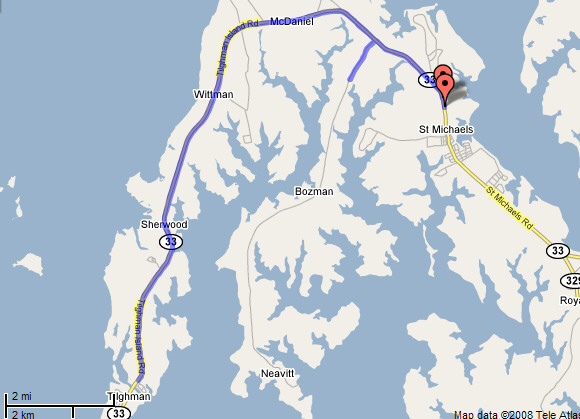
| 0 km START | US Route 33, just north of St. Michaels, just past Perry Cabin Road. Start near speed limit sign. Proceed north on Route 33 out of town. Keep following the road for 19 km as it gradually curves to the left until you're heading almost due south. |
| 5 km | Old Claiborne Road intersection |
| 10 km | Bay Shore Road intersection |
| 15 km | Punch Point Road intersection |
| 19 km | TURN AROUND by public park with gazebo on right (park has portapotties in summer) just before Knapps Narrows bridge |
| 20 km | Deep Harbor Farm Road intersection |
| 25 km | after Grafton Manor Lane |
| 30 km | Walker Turn Lane at boat ramp sign at McDaniel |
| 34.8 km | TURN RIGHT (southwest) on Rt 579, Bozman Neavitt Road |
| 36 km | TURN AROUND on Rt 579 at Willow Oak Farm road |
| 37 km | TURN RIGHT (southeast) on Rt 33 toward St. Michaels |
| 40 km FINISH | Rolles Range Road intersection (approx. 600 meters before Perry Cabin Park on your right). |
|
Disclaimer: Use at your own risk! Please use extreme caution on these highways particularly at the two highway turnarounds. Cars can be moving at closing velocities around 100 mph.
|
|
 Contact us at:
![]()
All content copyright 2008 N. Toby.
All rights reserved.
This page updated
03 Sep 2009.
![]()
![]()